Surviving Santiaguito: Lucky Volcano #13
It was on the way to hike Santiaguito, the most active volcano in Guatemala, that I asked Rachel, “Will this be the 13th Guatemalan volcano that you’ve hiked, too?” It was. Lucky #13 for both of us. Knock on wood that our 13th wouldn’t be our last!
Rachel, Russell, and I were mostly excited, but all a little
nervous to be hiking Santiaguito, “Guatemala’s youngest and most dangerous
volcano.” [1] The volcano erupts nearly
every hour, and we planned to sleep right next to the crater, crossing our
fingers that the wind wouldn’t blow the wrong way and shower us with flying
rocks and lava.
Our friend Ben, a guide from Quetzaltrekkers, had hiked it
before and was excited to take us up. He
assured us that the hike was “More of an adventure than just a trek,” and estimated
it would take us 8 hours of hiking each way.
That’s a long trip, when you consider that our group can generally make
it to the top of any volcano here in Guate in 4-6 hours. But we were totally up for it.
By 6:20am, we were at the base of Volcan Santa Maria, and
the sun was just beginning to rise. We
hiked up to the mirador overlooking Santiaguito and stood watching our first
eruption at 8am.
 Then the real hike began.
From the mirador, we began a descent through dense jungle. On Ben’s supply run, he’d used a machete to
cut back some of the most offending plants, but vegetation was still thick, and
I was glad Ben had advised us to wear long sleeves to protect our arms from the
foliage. We witnessed another eruption
when we were maybe halfway down the jungle, and soon ash was raining from the sky. It was only 9am, and we were already covered
in a thin layer of gray dust. The plants
around us were covered too, and I got the feeling that everything within a few
miles’ radius of the volcano is perpetually covered in ash.
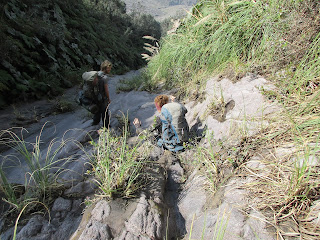
After two hours of our steep descent, we broke out onto an
extinct lava flow which we followed down to the base of the valley. The rock was slick, and at various points, we
sat down and used it as a slide rather than risk a foot flying out from under
us.
 |
| Butt sliding was definitely the way to go! |
After about 4 ½ total hours of hiking, we emerged from the
lava river to the area Ben calls the Field of Death, a wide valley strewn with
large boulders and not much else. There,
we each hid 2 liters of water so that we wouldn’t have to carry it up
Santiaguito and would have some in reserve to climb up the lava river the next
day. We also stopped to have a snack
(Ben shook his head each time we stopped and Rachel or I offered a new snack
from our packs. He joked that even if he
forgot all our food, the four of us
could probably have survived just on the snacks that Rach and I had packed).
At 11:11am, with a silent wish for a safe night at the
crater, we started the rocky ascent up towards Santiaguito. The path was steep, and we used the boulders
as steps, picking our way in and around them.
We stopped halfway up to rest, and while not at my limits, I definitely felt
tired. But with one final push, we
reached the first beach—a flat, sandy area with green cliffs looming on each
side. We rested, then continued
straight up and then through another rock field to get to the 2nd
beach.
 |
| The 1st Beach |
The second beach—another open, sandy area—was dotted with
impact craters left by rocks thrown from the volcano. Any rock thrown with enough force to make a
hole the size of my head in the sand would surely kill a person. My nervousness grew.
We continued on, scrambling over more rocks to make it to
the third and final beach before the campsite.
Ben paused at the third beach, looking up at the final rock face we
would have to top. “I wish the fog would
clear so you could see this part,” he told us.
But after a few moments, it was clear the cloud engulfing us wasn’t
moving, so we started our ascent. I was
secretly glad we wouldn’t be able to see the looming rock face. Climbing it was hard enough, without seeing
how far I had yet to go.
 |
| The final climb |
We edged our way up that final incline, clinging to the side
of the wall, putting our weight on hardened ash outcrops that felt like they
might give way at any moment. There were
very few actual rocks to step on, for a while.
And then we reached the final rocky slope. Ben actually had Rachel and I pass our packs
up so we could climb the last stretch without the bulky weight on our
backs.
Prior to the trip, I’d read a blog that described the climb,
calling the last challenge to the hike a “30 foot vertical rock climb” with no
ropes or equipment. Ben had assured us
that there was no actual rock climbing involved, but we all agreed the last
scramble was probably what the writer had referred to. It was not vertical, and there were plenty
of hand and foot holds to make it a relatively easy climb, but it was certainly
menacing. Ben joked that the blogger
would have been better off claiming the last obstacle as a “300 foot nearly
vertical slope,” because that’s the truth, and doesn’t it sound more intense
than a mere 30 feet?
We made it up to the campsite and cleared the small rocks
covering the sand to lay down our tent.
Just as we did so, it started to rain.
Rain?! The end of January in Guatemala is the peak
of the dry season; there is no way any of us were expecting rain. In fact, Ben had planned to sleep outside to
watch for eruptions. There was no
denying the water falling from the sky, though, so Rachel, Russell and I jumped
into the tent to wait it out. Ben passed
in lunch, then went to hang out in the rock nook he’d found previously—a spot
carved out almost like a chair with an overhang that kept him dry. After perhaps half an hour, the rain stopped,
and we emerged once again to look on the crater directly across from our
campsite.
This is what I love about Ben: he’s the definition of a “glass
half full” kind of guy. While we all could
have complained that the rain spoiled our afternoon, Ben emphatically stated, “Man,
we were so lucky the rain hit when it did.
Imagine climbing up that last stretch in the rain! This worked out really well.”
The rain began again, and it ended up raining for almost a solid six hours, finally petering out around 9pm. Ben emerged from the tent to cook us dinner at 10pm (because we all agreed hiking on empty stomachs the next day would not be a good idea), and then we returned to bed. But we essentially spent the time from 4pm until 5:30am inside the tent, sleeping.
We heard a few soft rumblings in the night, but we could
never tell whether they were rock slides (which happen frequently), more
thunder, or the volcano venting smoke.
It’s funny. Prior to
the hike, Ben told us he could guarantee that during the night, sleeping at the
campsite, each of us would feel real fear at being so close to the
volcano. I felt my fear standing on the
mirador at the beginning of our hike watching the eruption from a
distance. And as we hiked, I reminded
myself over and over that fear takes an enormous amount of energy, but really
does a person no good, so at the campsite, I planned to push my fear aside and
not let it in. But when we arrived at
camp, I didn’t have to. I didn’t feel
afraid at all once we were at the campsite, staring the crater in the
face. Maybe it’s because there wasn’t a
major eruption while we were there. Or
maybe the anticipation was worse than the actual event; whatever the case, I
was relaxed and had a great night’s sleep.
Just before dawn, Ben woke us to see the glowing
lava on the side of the volcano that wouldn’t be visible in the daylight. As the sun rose in a clear sky, Santiaguito graced us with a
small eruption that continued for perhaps 15 minutes, smoke puffing straight up
into the sky.
 |
| My view of the eruption from inside our tent |
 |
| Morning coffee and a volcano view |
The hike down the
mountain offered a new perspective, as the sun was out and the day was
clear. Everything was beautiful, and I
snapped tons of pictures. (And this time,
we could see every inch of that final climb as we picked our way slowly down
it).
 |
| Looking down from the campsite. The patch of dark sand on the left is Beach #3 |
 |
| The arrows point the route we took. Can you spot Russell? |
The walk back was just as difficult, if not more difficult,
than the trek to the crater. There were
equal parts downhill and steep uphill, and we worked every muscle in our
already-tired legs. When we were about
2/3 of the way through the dense jungle right before we arrived again at the
mirador (much harder uphill than it
had been going down!) when we stopped to catch our breath and heard a massive
eruption from Santiaguito. Though we
were well over a mile away, it rained ash on us for the next thirty minutes or
so. I was very glad of our timing, and
that we hadn’t been at the campsite for that eruption. I have a feeling I would have felt the fear
Ben spoke about.
By the time we made it back to the QT office, it was nearly
5pm. Our packs and clothes were covered
in ash, our legs were tired, and we were completely content at our
accomplishment. The three of us returned
to our hotel for a shower, then met Ben at the best Indian restaurant in
Guatemala for a delicious meal to end our adventure right.
 |
| Sabor de la India--you do things right. |
The whole weekend reminded me what life is really all
about. It’s about surrounding yourself
with positive, energetic, enthusiastic people, and it’s about celebrating the
beauty that is all around us. It was much
needed and well appreciated.
[1] http://www.enjoyguatemala.com/guatemala-volcanoes/


Comments
Post a Comment